Search Blog

You can search this blog. Type the topic or search argument in the box below and hit the Search Button.

Search This Blog

Copyright

Original Text and Graphics Copyright 2015 by David Griffin, windsweptpress.com

Tuesday, March 25, 2014


                   Around Town

                   ... before we got here

                             Utica, NY

              (If necessary, click photos to enlarge.)

         Click for:

                Bagg's Square photos


                Newspaper Advertising   click to enlarge

               Aerial Perspective Map
         
                 
               Detail Maps of Old Utica

               Lower Genesee Street

               Broad, Main and Whitesboro Streets
    
               The Erie Canal 

               Union Station

               The Busy Corner I

               The Busy Corner II

               The Busy Corner III
               
               Bleecker Street

               St. John's Church and UCA

               Lafayette Street I
              
               Lafayette Street II

               Elizabeth Street I

               Elizabeth Street II

               Elizabeth Street III

               The People of Utica

               Columbia Street
               
               Catch All 1

               Catch All 2

               Catch All 3

               Genesee St. South to Court St. 

               Genesee St. - Hopper St. to Genesee Hill

               Cornhill

               Utica's Trolleys and Buses

               Railroads

               Other Places of Interest


Lower Genesee Street, North of the Erie Canal


OK, it's probably time to come down.  In the distance left, the spires of St. John's Church.  No, I don't call it "Old St. Johns."  It's only 70 years older than the day I was baptized there and that's not much older than it was all of my life.  My Great Great Grandfather Michael, fresh from the ould sod was married there in 1826 (I think in an earlier structure before the fire) .


My notes say these buildings were on the corner of Whitesboro and Genesee Streets.  It must be quite old, from the first half of the 19th century.


The Averell House stood by to serve you lunch or dinner.     In the grey tone bird's eye view of Bagg's Square and Utica, Averell's was down next to the railroad tracks on the west side of the square.  

1843


The Utica City National Bank must have really grabbed the attention of anyone coming into the city.

My eyes are tired tonight.  A volunteer to interpret the writing at the bottom of the card would be appreciated.


Above, this photo of the City National Bank Building was color-enhanced by our friend Kit from the "Clipper's Busy Corner" proboards forum.  (clipper220.proboards.com)  Thanks, Kit!


Today


Fiona and I believe the Roberts Hardware Store was in this area of lower Genesee Street. 


I assume this ad was for the the Roberts Hardware/Sports store.


Below, the John Roberts Store, "Flanel, Blankets and Wash goods."


An ad in the Herald Dispatch for the John Roberts dry goods store.


Thanks to Fiona, here is a photo of The Leader Store's building just below the Hump Bridge over the Canal on Genesee Street.  The Leader Store was evidently a retail chain or organization of stores.  Perhaps that is what is meant by the term "cooperative store" in the Retail publication also shown below.


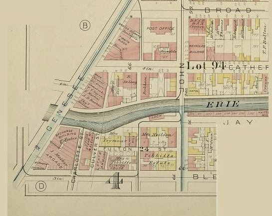
Here's a shot looking North from the Erie Canal Bridge.  We're looking in the opposite direction of Hans' view in the last post.  My notations on the 1920's era card are from a post I made elsewhere as I tried to remember what the block was like when I was in high school in the late 1950s.  They're self explanatory, except for the green rectangle that outlines the building in which I held an after-school job.. 


This photo is from the late 1940's.  From what I remember of it, the building was made to look like a giant ice sculpture from all the water poured on it by firemen.  As kids we called it the Allen's Bakery Fire which was the business on the first floor and I think the part of the building where the fire started. The event goes by other names and perhaps you know and would comment.  Go ahead and comment on anything mentioned here.  You can do so on the FB post that pointed you here.


A nice view of the Mann Building on the corner of Genesee and Broad Streets.


Above: If I were standing here in the middle of Genesee Street looking east out Catherine in the 1950's, the First National Bank on the left would have been replaced by Mike Cuda's Mobil gas station.  And part way down Catherine on the right was the loading dock and back of the Observer Dispatch building.  Part way down on the left was the back of the Post Office.


Come ahead almost a half century and I believe that's Bernie Phillipson's Army-Navy (don't ask whose) Store on Genesee and ... was it Liberty Street?    I could use some help.  I remember it well, just not exactly where it was.

Next time we'll post photos and postcards of Side Trips away from Genesee St., east and West along two major side streets.  And then we'll continue our way up to the Erie Canal and on to the Busy Corner.

Comments welcome!  Rather than make them here, it would be best (and a heck of a lot easier) to comment on the FaceBook post that sent you here.

Monday, March 24, 2014

Broad, Main and Whitesboro Streets

If you didn't come to Utica on the train in the 1940's you may have arrived by automobile.The old 5S (South of the Mohawk) was a popular route, taking you from Albany through every small town in existence along the old Erie and Barge Canal routes.  You can still drive it today for the nostalgia.  Come west out of Ilion and go straight instead of turning left on to the "new" 4-lane  5S.  You'll be on what's called Acme Road.  It will turn into East and West Main Streets when it brings your through downtown Frankfort.  The rest of the ride into Utica is on what today is called Southside Road and it  chugs along beside the old railroad tracks (and Erie Canal route) as well as past the remnants of Cappy's  (Capuano) old junk yard before meeting Ferguson Road.  Soon you'll see the  iconic railroad bridge up ahead.  Stay the course and you come into Utica on Broad Street, Utica's major street of commerce many, many years ago.
 Dozens of trucks might be seen on a typical weekday morning in the middle of the last century as drivers topped their tanks with gas and got ready for a haul down the valleys of the Mohawk and Hudson Rivers to the docks lining both sides of Manhattan.


Just before you reach the Mann Building on the corner of Genesee and Broad Streets,  you would have passed the old Federal building and Post office if you arrived before WW One.
The new post office and federal building replaced it after the  war.  Styles and tastes change, I suppose, but I much prefer the old architecture.  The new architecture in my mind speaks more to a militarily strong nation.  The old spoke more to our mutual aesthetics.  And, if you like, to our soul.


I don't remember exactly what street it was on, but it was down there somewhere.  The Imperial Restaurant.  My Aunt Margaret (actually a first cousin, once removed and my Godmother) was a cook there years ago.  Wow, her meals were great and I well remember Thanksgivings at her house.  Delicious food and enough cigarette smoke to choke a horse, as she would say.  I've chronicled a particular Thanksgiving in the story Pack of Lies, located here:


http://www.windsweptpress.com/packlies.pdf
Master Story list at http://www.windsweptpress.com/stories.htm

(I've since figured out where the above scene and the Imperial were located. The Amoco gas station in the back ground was converted to the Greyhound Bus Station in the 1950's.  So that's Hotel Street running right to left.  The Imperial was located directly across from the Devereux Building on Oriskany Boulevard, between Hotel and Genesee Streets.)


This the Fraser Store fire, for dramatic effect.  Hey, I'm a storyteller, not an historian.


Across the intersection stood the Crouse Block, an immense building and storehouse for cloth goods and machinery.  It burned down in 1897 in a huge fire that injured many.  The fire took the lives of Firemen John O'Hanlon and Isaac Monroe when the floor they were on collapsed into the conflagration below.  O'Hanlon had been a hero the year before at the colossal Genesee Flats fire (today replaced by the Obliston on Genesee Street and Clinton Place) when he "rescued many women and children and was not afraid to climb to the highest story in order to save them. He was badly burned about the face and hands." (Herald Dispatch, March 10, 1896.)


John O'Hanlon's memorial monument stands today in the St. Agnes Cemetery on Mohawk Street.  My father, a former UFD fireman (tillerman) as well as long-time Observer Dispatch pressman, often walked us by O'Hanlon's statue on the way to his parents graves.


Seymour House on Whitesboro St.
Let's go back down Genesee Street for a short distance and quickly run out Whitesboro Street.  In the first half of the 19th century the stores and factories on Whitesboro Street soon ended and the homes of the wealthy business owners could be seen when strolling through their lovely neighborhood.  If you remember the Utica Birdseye/Baggs Square painting, here is a detail from the bottom right corner where you can see a few of the comfortable homes along Whitesboro Street.


Farther out Whitesboro Street in later years were a number of manufacturing concerns, including Horrocks-Ibbotson, shown below in the 1950's.


H-I made a number of different sport fishing items, including bamboo fly rods.  In the 1930's my mother worked there, happy to land the job after more than a year spent standing behind her counter at Woolworths for 49 hours each week and about $17 pay.   Her exciting new job at H-I was to tie the line guides on the rods, done with thread and glue.  Her boyfriend also worked there.  They were never to be, which is OK with me because I kind of like looking somewhat like my Dad whom she met later.  I fictionalized my Mom's story  and wrote the novella, "Jimmy Bean."  You can buy it on Amazon, hard copy or Kindle, or download it for free from my master story list at   http://www.windsweptpress.com/essays.htm  (I never resist the urge to plug a story.)  Mom would either kill me if she were alive or thank me for giving her a voice again through my story.


Here is one in a series of successful advertising posters distributed by H-I in the early years of the 
 20th century


I "photo-shopped" this scene (actually Gimp) of Mom at work in 1936 at her workbench in the H-I factory.  I modified a '30s house dress, stole reels and rods from old fishing catalogs and made my mother a bit prettier than she probably was.  (You're welcome, Mom.)


Also on Whitesboro Street was The Saturday Globe, a publishing phenomenon of Utica you probably never heard of.  The Saturday Globe  was a national newspaper which published from 1881 to 1924.  It reached a circulation peak of almost 300,000 and was read from Maine to California each week in thirty-one localized  editions.  It was noted for the way it told a story and for an early use of photographs instead of wood cuts.  It pre dated a copy-cat publication, The Saturday Evening Post, by fifteen years.


I don't think the New York Bakery was on Whitesboro Street, but it was in the neighborhood, so let's get a dozen donuts.  I can remember my parents stopping to buy rolls for Sunday night supper.

And of course, we have to visit the MotherShip where I was born.  The original St. Lukes Hospital on Whitesboro Street.  I think it's still there.  Is it a rest home now?  If so, I suppose I could arrange to have come into the world and gone out in the same building.  Maybe on the same floor.


Sunday, March 23, 2014

The Erie Canal


A picnic along the Erie Canal's towpath.

A canal.  What a neat idea!  No need to lug, drag, cart or push your worldly goods to their destination.  Not when you can simply float them down a waterway   But here's the problem.  Rivers don't always go where you might want them to go.  So you can build your own.  Governor Clinton at the close of the 18th century became

Canals of NY State
convinced he should extend the navigable reaches of the Hudson River across New York State to the tip of the Great Lakes and bring from the midwest what he needed to New York City.   Traders would bring wheat to the city's ports for sales overseas.  More importantly, such a canal allowed eastern businessmen to sell what was made in New York to all those folks going west who were too busy with the going part to have  yet found the time to build their own factories.  The Erie Canal provided a marked reduction in shipping costs.  The final price of everything at the delivery point was much cheaper.  New York's wares would be competitive in Chicago.  A ton of stuff that had cost $100 to ship by wagon from New York City to Buffalo cost only $10 on the canal.  The sale of cheap goods that hadn't been 't possible at remote locations because of transportation charges now became marketable hundreds of miles away.  What an increase in the size of your
Ilion, E. Main Street 1906
markets!  It was like getting up in the morning and discovering ten times more customers outside your shop waiting to come in and make purchases.  Why, a smart fellow could even have a business out on the frontier in some far-flung place like that little village up on the Mohawk near the old Fort Schuyler
.


Erie Canal Data
The little town on the Mohawk dominated by Bagg’s tavern was quickly transformed.  Trade brought money, which brought banks and insurers.  All of it brought people who needed food and shelter, clothing and other goods.  It wasn’t long before what became Utica was a veritable economic engine.


The Erie Canal was replaced by the wider, deeper Barge Canal ca. 1916.  The old Erie was filled in, according to the Oneida County Historical Society in the late 1920's.  See last sentence of the caption for the photo below.


The weigh lock at the foot of John Street.  We need another volunteer to interpret the hand written note!


And in a sense Utica came to the canal, with businessmen standing in line to build banks, printing houses and a myriad of  factories producing all kinds of goods.  I'll refer you to the maps posted earlier in this thread, but you can visualize the Erie Canal coming right down Oriskany Blvd. In fact, that street was formed when the canal was filled with dirt in later years after the Barge Canal was opened in 1921.  And it was at that time the Mohawk River's presence in Utica was moved about a mile north away from the railroad tracks.  Trains eventually got more attention and more business than either canal. But the canal started it all.


Unreadable, but you can see the rise from Albany to Buffalo.


Vicinity of Hotel Street


The canal and its Genesee St. crossing were a fixture in downtown Utica.  Here's a view from the top of City Hall.  You can't see much of the canal, but notice the bridge down past Bleecker Street.


The Erie Canal bridge didn't look like much from atop tall buildings, but down on the street it was a landmark.  Below is a very tight zoom in on a print from a glass plate negative of the Busy Corner.  The photographer stood somewhere in the intersection of Elizabeth and Genesee Streets.  You can see the canal bridge in the background and the small raised hut above the street.


The Genesee Street bridge over the canal was often called the Hump Bridge.  I had wondered how the hump helped the passage of boats with it's increased clearance above the canal water level when right beside the hump the bridge was flat.  Turns out the hump was not for clearance.  Even the flat parts of the bridge were sufficiently high above the water.  The hump, using the principle of an arch, was much stronger than a flat bridge and was necessary to bear the heavy weight of the trolley cars.  Before the Hump was constructed the State had closed the bridge because of the damage done to it by the trolleys.  Passengers coming from the rail station then had to disembark at the bridge, walk over it and and catch another trolley south up Genesee Street. The Hump eased travel and traffic congestion by allowing a trolley to pass over the canal.


Above is the 1883 Utica Map showing the canal crossing Genesee Street.  Bleecker Street is at the bottom of the map segment, Broad Street at the top.


My favorite Busy Corner shot taken from the canal bridge.  The scene is evidently sometime after the Barge Canal opened officially in 1921.  Notice the hand railings.


Above, evidently an accident, according to Fiona's notes.  That's Genesee St. in the background, before the Hump Bridge was constructed.


 Looks like a Celebration.   Canal boat is fit out for passengers, which I believe was unusual since most times passengers fit in among and on top of the boxes.


 Leaving Middletown in 1916.  My notes say this was the last barge to leave Middletown on the Erie.


A mix of people and freight.  Not much headroom under the bridge.


The Locks at Little Falls.  Looks like a tortuous route.


Erie Canal Lock.  Primitive by today's standards, but it worked well.


Today the Observer Dispatch sits along side where the canal used to flow past John Street to Genesee Street.


 The OD in the 1950's.


An old lock in Ilion being dismantled in 1936.  Beautiful stone work.


West Shore RR's iconic bridge across the old Erie Canal.


Towpath crossing in Frankfort.  No longer in use in the 1930's.


Along the canal near the Frankfort lock in 1906.


East Frankfort in the moonlight.


The new Barge Canal in 1916 crosses the Erie Canal near Herkimer.


Ilion dry dock in 1905.


Ilion in 1908.


E. Main Street in Ilion, 1911.


A more architecturally interesting neighborhood where the Erie Canal runs through Syracuse. Many of the buildings are still in place today here at the intersection of Salina Street and Erie Boulevard.


The lock at Lockport.  A different terrain from Utica's.

With one exception, the equipment that runs the locks on the Barge Canal today is the original equipment installed in 1916, according to a lock repairman I spoke with one evening about ten years ago.  When a part is needed, it is made in a machine shop.  The exception is that electrical power for the lock motors is drawn from the public grid we all use.  Such was not available everywhere or not dependable  in 1916.  So each lock had a separate building or "steam house" where coal fired a steam powered generator for the necessary electricity.  I'm not sure why, but at the lock's I've stopped to visit, the steam house is always closer to the road by a good distance.
 

The old Chenango Canal ran south to Binghamton, through Utica where the today's Arterial lies.  When I was a kid, that strip was a railroad, I think the Delaware, Lackawanna and Western (DL&W), but I'm not sure.  Very near the old Burrstone Bridge was a roundhouse and turntable used for servicing and turning around the switcher locomotives we saw on the rails daily.  And I remember a small building with a front porch evidently used by train personnel as a lunch room and bunk house. A sign sat up on the roof, "Do Drop Inn."

All that was left of the canal in my memory was "Milky Pond," as we called it.  From under the Burrstone Road Bridge down behind the west end of Murnane Field we boys walked south along the tracks for a quarter mile to the pond.  It was the one spot where there were no adults around to stop us from setting off firecrackers, swear to our hearts' content and speculate about girls.


Above is the Burrstone Road bridge under which ran the railroad when I was a kid and the Chenango Canal when my grandfather was young.  And today, of course, a much larger bridge flies over the North South Arterial.  The photographer would have been standing at the very west end of Murnane Field, his lens pointed toward York Street.  In the 1950's we rode our sleighs down the hill that is unseeded in the photo but was smoothed out and grass covered by our time.  Opposite the hill and bridge, down at the lower level, assessable by a cinder road under the bridge from the south end of Lincoln Avenue , was a brick building that housed the Utica Products Company.  I remember the sign on the building and the employees inside watching us through the tall windows, nothing else about the business.  If one of the other kids told me what they made and/or sold there, I don't remember.  Besides, I wouldn't trust it because I'm sure it would have been topical.  As in, "I hear they make nuclear bomb detonators in there!"

Needless to say, the railroads supplanted the canals.  And then the rails went into decline when the auto and truck industry convinced the various governments to build roads, roads and more roads.

We'll take a very quick look at railroads next, mainly from the perspective of  Utica's Union Station.     

I can't begin to thank all the institutions from whom I stole most of the graphic images above.  Hey, it's the Internet! 


April 25, 2014:   Added more photos.

 
 In the above photo of the Erie Canal bridge on Genesee St. just north of the Busy Corner,  you can see the reflection of water just this side of the Devereux Building,  the structure in the foreground that splits Hotel Street from Genesee Street to form Franklin Square.  This is a great shot of the south end of the bridge.  An electric trolley approaches the bridge.  I wish I had an explanation of whatever that is running parallel to the side of the bridge on the right.


 Above, locks at :Little Falls.


 These are horses, of course, or so they appear to me. The canal used mules, not horses.


 A weigh lock.  By the looks of the surrounding buildings, this is not in Utica, but of course the City had one or more.


Above  is a close-up of a weigh lock in Utica with a launch along side evidently used for maintenance of the canal.  This is an enlargement from one of the glass negatives shown below.