 |
| A picnic along the Erie Canal's towpath. |
A canal. What a neat
idea! No need to lug, drag, cart or push
your worldly goods to their destination.
Not when you can simply float them down a waterway But here's the problem. Rivers don't always go where you might want
them to go. So you can build your own. Governor Clinton at the close of the 18th
century became
 |
| Canals of NY State |
 |
| Ilion, E. Main Street 1906 |

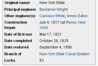 |
| Erie Canal Data |
The Erie Canal was replaced by the wider, deeper Barge Canal ca. 1916. The old Erie was filled in, according to the Oneida County Historical Society in the late 1920's. See last sentence of the caption for the photo below.


The weigh lock at the foot of John Street. We need another volunteer to interpret the hand written note!
And in a sense Utica came to the canal, with businessmen standing in line to build banks, printing houses and a myriad of factories producing all kinds of goods. I'll refer you to the maps posted earlier in this thread, but you can visualize the Erie Canal coming right down Oriskany Blvd. In fact, that street was formed when the canal was filled with dirt in later years after the Barge Canal was opened in 1921. And it was at that time the Mohawk River's presence in Utica was moved about a mile north away from the railroad tracks. Trains eventually got more attention and more business than either canal. But the canal started it all.
 | |
| Unreadable, but you can see the rise from Albany to Buffalo. |
 |
| Vicinity of Hotel Street |

The canal and its Genesee St. crossing were a fixture in downtown Utica. Here's a view from the top of City Hall. You can't see much of the canal, but notice the bridge down past Bleecker Street.

The Erie Canal bridge didn't look like much from atop tall buildings, but down on the street it was a landmark. Below is a very tight zoom in on a print from a glass plate negative of the Busy Corner. The photographer stood somewhere in the intersection of Elizabeth and Genesee Streets. You can see the canal bridge in the background and the small raised hut above the street.

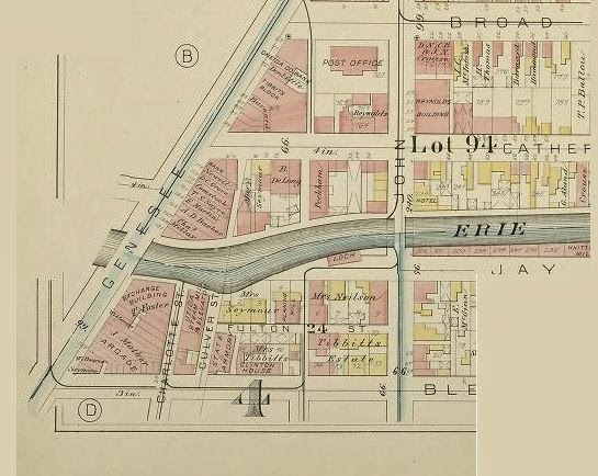
Above is the 1883 Utica Map showing the canal crossing Genesee Street. Bleecker Street is at the bottom of the map segment, Broad Street at the top.
My favorite Busy Corner shot taken from the canal bridge. The scene is evidently sometime after the Barge Canal opened officially in 1921. Notice the hand railings.


Leaving Middletown in 1916. My notes say this was the last barge to leave Middletown on the Erie.

A mix of people and freight. Not much headroom under the bridge.
 |
| The Locks at Little Falls. Looks like a tortuous route. |


Today the Observer Dispatch sits along side where the canal used to flow past John Street to Genesee Street.


An old lock in Ilion being dismantled in 1936. Beautiful stone work.


Towpath crossing in Frankfort. No longer in use in the 1930's.
Along the canal near the Frankfort lock in 1906.

East Frankfort in the moonlight.

The new Barge Canal in 1916 crosses the Erie Canal near Herkimer.

Ilion dry dock in 1905.

Ilion in 1908.

E. Main Street in Ilion, 1911.

A more architecturally interesting neighborhood where the Erie Canal runs through Syracuse. Many of the buildings are still in place today here at the intersection of Salina Street and Erie Boulevard.

The lock at Lockport. A different terrain from Utica's.

With one exception, the equipment that runs the locks on the Barge Canal today is the original equipment installed in 1916, according to a lock repairman I spoke with one evening about ten years ago. When a part is needed, it is made in a machine shop. The exception is that electrical power for the lock motors is drawn from the public grid we all use. Such was not available everywhere or not dependable in 1916. So each lock had a separate building or "steam house" where coal fired a steam powered generator for the necessary electricity. I'm not sure why, but at the lock's I've stopped to visit, the steam house is always closer to the road by a good distance.
The old Chenango Canal ran south to Binghamton, through Utica where the today's Arterial lies. When I was a kid, that strip was a railroad, I think the Delaware, Lackawanna and Western (DL&W), but I'm not sure. Very near the old Burrstone Bridge was a roundhouse and turntable used for servicing and turning around the switcher locomotives we saw on the rails daily. And I remember a small building with a front porch evidently used by train personnel as a lunch room and bunk house. A sign sat up on the roof, "Do Drop Inn."

All that was left of the canal in my memory was "Milky Pond," as we called it. From under the Burrstone Road Bridge down behind the west end of Murnane Field we boys walked south along the tracks for a quarter mile to the pond. It was the one spot where there were no adults around to stop us from setting off firecrackers, swear to our hearts' content and speculate about girls.

Above is the Burrstone Road bridge under which ran the railroad when I was a kid and the Chenango Canal when my grandfather was young. And today, of course, a much larger bridge flies over the North South Arterial. The photographer would have been standing at the very west end of Murnane Field, his lens pointed toward York Street. In the 1950's we rode our sleighs down the hill that is unseeded in the photo but was smoothed out and grass covered by our time. Opposite the hill and bridge, down at the lower level, assessable by a cinder road under the bridge from the south end of Lincoln Avenue , was a brick building that housed the Utica Products Company. I remember the sign on the building and the employees inside watching us through the tall windows, nothing else about the business. If one of the other kids told me what they made and/or sold there, I don't remember. Besides, I wouldn't trust it because I'm sure it would have been topical. As in, "I hear they make nuclear bomb detonators in there!"
Needless to say, the railroads supplanted the canals. And then the rails went into decline when the auto and truck industry convinced the various governments to build roads, roads and more roads.
We'll take a very quick look at railroads next, mainly from the perspective of Utica's Union Station.
I can't begin to thank all the institutions from whom I stole most of the graphic images above. Hey, it's the Internet!
April 25, 2014: Added more photos.

In the above photo of the Erie Canal bridge on Genesee St. just north of the Busy Corner, you can see the reflection of water just this side of the Devereux Building, the structure in the foreground that splits Hotel Street from Genesee Street to form Franklin Square. This is a great shot of the south end of the bridge. An electric trolley approaches the bridge. I wish I had an explanation of whatever that is running parallel to the side of the bridge on the right.

Above, locks at :Little Falls.

These are horses, of course, or so they appear to me. The canal used mules, not horses.


Above is a close-up of a weigh lock in Utica with a launch along side evidently used for maintenance of the canal. This is an enlargement from one of the glass negatives shown below.
