
The
Lincoln Avene bus ran from under the Burrstone Road bride down to State Street
and then made a right on to Columbia. It
crossed Genesee Street in
the lee of Grace church and
then came back west along the side of Daws Drugs to the Busy corner. I find myself amazed to not recall which
street the bus turned down ... Charlotte? John? ...
to accomplish the loop back at the end of the run.
I suppose I always jumped off at Grace Church when I was in the fifth grade,
anxious to get to Woolworth's to buy more paper and ink. If I had money I bought those small three by
six inch pads and back ink for my stamp pad.
My little desk at home was stuffed with those paper pads, bottles of
ink, my small rubber type printing press, my crystal radio and a broken clock
from the dashboard of my Uncle Walt's 1937 Chevy. I've always liked clocks that don't work. See "Waiting For Me" at
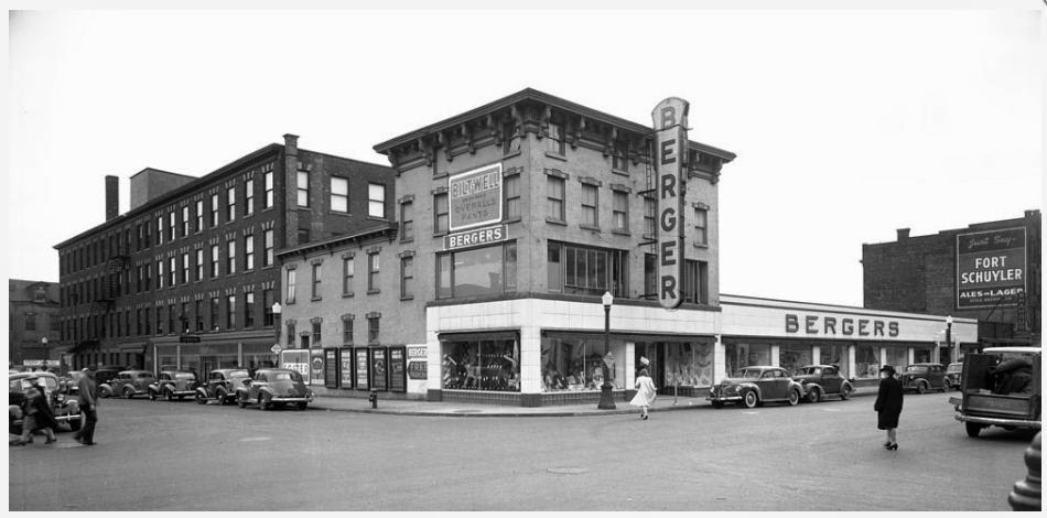
Columbia Street was unusual in that it comtained many retail stores, just like Genesee Street. But somewhat like Bleecker Street, Columbia Street's stores were more family and bargain oriented ... for the most part. Berger's Department store was here and before the State Street Mill opened in the late 1950's, you couldn't find better bargains (price wise, anyway) than at Berger's.
To bore you further with my journals, Berger's figures prominently in my story, Boots, at the following url.
http://www.windsweptpress.com/boots.pdf or .doc
Master Story List at http://www.windsweptpress.com/stories.htm
Master Story List at http://www.windsweptpress.com/stories.htm

The intersection of Genesee, Columbia, Elizabeth and Seneca Streets was almost as busy as the Busy Corner.. In fact in the 1940s and possibly earlier a traffic policeman was assigned just like the more famous intersection a block to the north. Above, the photographer was standing in the road with his back to Grace Church, shooting west. (Eventually standing in the road with your undivided attention focused into a camera's viewfinder would get pretty dangerous.) In the photo, you can see City Hall up the street to the left and directly in front of us is the Gardner Building, it's face slightly turned from Gensee Street and lining up more with Seneca. As we saw in an earlier post, the Gardner Building burned in 1947. I don't know if was refurbished after the fire and was still around when I was a kid. It's gone today, according to Google Maps.
And so is the City Hall, I was surprised to find as I looked around town using the satellite photos.

By the way, if the photographer from the Gardner Building photo above walked up Genesee a block and looked back on the Columbia Street intersection ... and his Time Machine shaved off a few years ... the scene before his eyes would be the following.

You can see the Butterfield House on the right, blocking your view of Grace Church, and the south end of Seneca Street that forms one of downtown Utica's Y intersections and one more opportunity for a triangular shaped building. (I'm searching for the names of these buildings and so far have discovered only one name, the Devereux Building at Franklin Square. Does anyone know the others?)
Following the commercial real estate around Utica in past years was somewhat of a sport, due to mergers, sales and the hectic business climate of the 1920s and 1930s. For example, on what I refer to as the "Rexall Corner," the southwest point on the Busy Corner, there was in 1900 a rather residential looking white faced building with a mansard roof. Later, in the early 1930s it was replaced with a new building owned by Citizen's Trust. Next we got Rexall's in the 1950s and in the meanwhile the bank building at the head of Seneca Street where it meets Columbia becomes the First Bank and Trust.

Anyway, back to Columbia Street ....

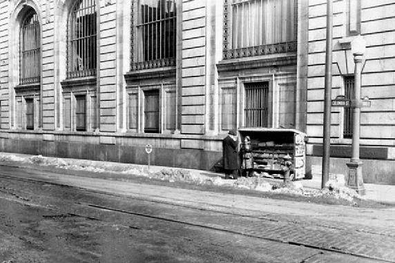
Clearing snow with a trolley and plow on Columbia Street with the side of the First Bank and Trust in the background. You can see the small newstand that occupied that space for years. Below is a photo of the news stand, famous in Utica for the woman who ran it, in better weather. Not much better, but at least it wasn't snowing.

Above, same bank, probably sometime in the 1960s. Photographer is standing on Seneca Street, maybe half way down to Lafayette. Below is a photo that appeared in an earlier post on Lafayette Street. When Marine Midland took over First Bank and Trust, they evidently displaced the building right next door as well as the A&P just down the street.

And below is a touched up photo of the bank building when it was called Citizen's Trust Company. Looks to be the late 1920s.

We don't seem to be getting very far down Columbia Street, do we? That's because I don't have a hell of a lot of photos of the streeet. But you probably guessed that.
Here again is the photo I ran at the top of this post. This time I've removed the bus I temporarily photo-shopped into the scene. Did you notice it had no driver?

When I was a junior in high school, I worked after classes for a wholesale company on lower Genesee Street and would often deliver watches to Sonne Brothers, the store on the corner of Washington Street on the left in the above photo. Although my employer considered himself a wholesale jeweler, he made most of his living selling electric fry pans. Sorry to keep interrupting while I plug my stories, but some of you may enjoy them. "Mr. Frypan" is here:
http://www.windsweptpress.com/frypan.pdf or .doc
Master Stories List at http://www.windsweptpress.com/stories.htm

Washington Street entrance.
And here is the certainly famous Berger's Deparatment Store. Certainly it was famous among working men's families.

Let's not forget St. Joseph's Church out on Columbia Street. It was later merged with St. Patrick's. My notes say the photo below is of the church's sanctuary. You'll see where St. Joseph's was located on the map farther down in this post.

And farther out Columbia Street ... before my time and yours ... was the first St. Elizabeth's Hospital. An older photo is shown below, followed by a portion of the 1883 map illustrating that it was just down the street past St. Joseph's Church.

On the left, below, is a wider view and on the right a close up. Look to the right of the hospital for St. Joseph's.

We'll go as far out Columbia as Eddie's Bar. I'm not exactly sure of its location. The photo below appears to be from the 1960s.

And finally, when we come back to Genesee Street, this is what we'll see today.
